10/27/2010

Welcome to "LAGO PUELO NATIONAL PARK"


Near the village, about 3 kilometers, is the gateway to the "LAGO PUELO NATIONAL PARK", created in 1937 as an annex of the "Los Alerces National Park" and in 1971 it was declared independent National Park and Reserve; it includes also a Strict Nature Reserve. It can be reached by paved route Nº 16, either in your own car or by bus from El Bolsón.

Route Nº16 to the National Park

Signs in the entrance of the Park
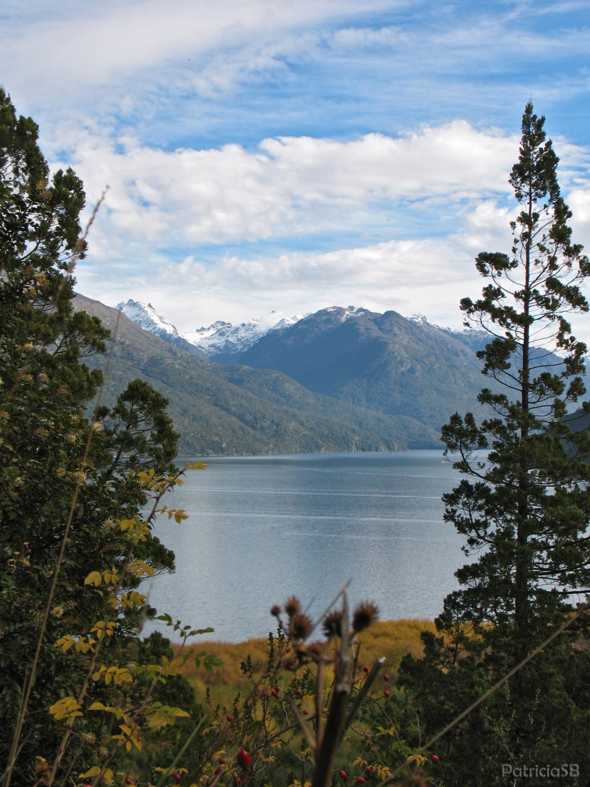
 This park protects the Andean patagonian forest in the transition to the Valdivian rainforest, which enters to our country in this place between the hills "Aguja Norte" (North Needle) and "Aguja Sur" (South Needle). The treasured landscapes are really stunning: the mountains of the Andes, the important moun "Tres Picos" (Three Peaks), the blue water of the lake and the lush vegetation.

Mount "Tres Picos" (Three Peaks)

General view of the Puelo lake
In the lake you can do both kayaking or motor boats trips. There are tours to differente points like:
  • "El Turbio", Turbio river mouth and where you can be off the boat and walk through the very small town,
  • "Los Hitos", al the border with Chile
Sailing across the lake

Puelo Lake
In the summer and sunny days, people enjoy a sandy beach called "La Playita", where you can swim because the water is warm. In this National Park you can practice hiking, river rafting, rock climbing, fly-fishing, bird-watching till you enjoy nature.

Puelo Lake and Mount "Tres Picos"
 There are several circuits for those who love trekking, one of the most beautiful is that called "Bosque de las Sombras" (Forest of Shadows) and the strangest is the "Pitranto Grande" (Big Pitranto). Both trails go into the forest, where you can see different type of trees: pitra, myrtle, mountain cypress, lenga, coihue, radal and many types of ferns.
Forest of Shadows
Forest of Shadows

Forest of Shadows
Pitranto Grande

Pitranto Grande

Pitranto Grande
This park is a refuge for the huemul, a small deer that is natural monument and is in danger of extinction. Another endagered animal is the pudú, the world´s smallest deer that lives in the chilean forests. There are also pumas, foxes, and other not so well known species like the huillín (patagonian otter) and monkey forest.
Many species of birds fly in these skies: chimangos, mandolins, thrushes and several types of ducks.


During high season (summer time) there are some coffe shops and grill areas, also thre´re two camping sites. If you like trekking, you can climb the Currumahuida hill through a path of 800 meters to a viewpoint located 150 meters height, which allows the observation of the lake and its beautiful surrounding area.


Lake´s Viewpoint

Viewpoint from the Currumahuida

Lake´s Viewpoint
The Botanical Garden of Lago Puelo is located inside the National Park and there are many hiking trails as:
  • The voice of the maple trail,
  • the Population Rietman trail,
  • the Cypress grove trail,
  • and the Pitras trail.
Botanical Garden

Voice of the maple trail
 I´ll try to let you more of this beautiful and special park in other posts. But I think that you would like this place and this refuge of nature...

10/15/2010

Welcome to LAGO PUELO

I´m beggining to let you know my place in the world: LAGO PUELO in the Parallel 42º Andean Shire, very near to the border with Chile. It´s located in a green valley al the foot of the Andean mountains but only at 170 meters above sea level. The "MAPUCHE" people, the first inhabitants gave the area the name of  PUELCO, that it means "eastern waters" (Puelo is a deformation word of Puelco). 

Welcome to Lago Puelo
 
Streets of Lago Puelo

Library

In this part of Patagonia there´s a microclimate, the village is surrounded by hills that keep it sheltered from the winds, so the winters are no so rude, snows a little but rains a lot. In the summer the warm and sunny days allow tourist to walk through the various circuits, practice rock climbing, fly-fishing or enjoy the beach of the lake.


Puelo Lake

Autumn in Lago Puelo

Autumn in Lago Puelo

The streets of the village are wide, the avenues have squares in the center and the sidewalks have also green areas. There is a trail that climbs the Currumahuida hill and that it shows the village from above. You can see that the buildings are low rise and the materials most used here are stones, bricks and wood from the area like the cypress wood. The roofs are of sheet metal and shops have their advertising signs made of wood too.

 
Lago Puelo from the Currumahuida Hill

Lago Puelo from the Currumahuida Hill
 
Restaurante near the main square

Streets of Lago Puelo

Typical building of Lago Puelo
 In the shield of the town, it can be observed the Cerro Tres Picos (Three Peaks hill), the Puelo Lake and a cypress, typical tree of this region. To the right is a branch of Rosehip and to the left a branch of hops, representing the agriculture. At the bottom it´s a hazel tree, only found in Puelo. At the top is a rising sun symbolizing the strenght and the future of the young town (Municipalidad de Lago Puelo).


(Municipalidad de Lago Puelo)

But the most beautiful place here is the Lago Puelo National Park, that we are going to know in another post... 


10/05/2010

Parallel 42º Andean Shire - EL BOLSÓN

Note: First of all, excuse me: I have to say that I´m trying to write this blog in English so you can read it, but I recognize that my English is poor...

My place in the world, Lago Puelo, is one of the villages that form the PARALLEL 42º ANDINE SHIRE (Comarca Andina del Paralelo 42º). This parallel is the border between two provinces: Chubut and Río Negro. But it is only a border in the maps and of jurisdiction because this Andean region functions as a whole thing.

The Piltriquitrón

 The largest town of this region is EL BOLSÓN, and in this post I will try to show you a little of it. It is situated in a fertile valley at the foot of the Andes and the Piltriquitrón Hill, on the banks of the Quemquemtreu river. The village has a special microclimate that helps to plantations such as berries and hop, used in the beers.

Pagano Square and the mount Piltriquitrón

Typical Street of El Bolsón

The first white man who arrived to the place was Captain Juan Fernández, searching the mythical City of the Caesars but in the area the "tehuelches" and the "mapuches" later lived for hundred of years. In 1880 some farmers from Chile were established. People of differents places of Europe began to arrive and settled down in El Bolsón such as Polish, Russian, German, Ukranian, Italian, Spanish... On 28 January 1926, some residents signed up the act of the initial administrative and political organization of the city.

Church (Nuestra Señora de Luján) and sculpture in Pagano Square

In the seventies a lot of bohemian young people of the "hippie" movement arrived to El Bolsón, changing their lifestyle. They came from the big cities like Buenos Aires, settled in the farms and made handcrafts. Till now you can see them in the Pagano square where the Regional Fair is a tourist attraction.


Regional Fair in Pagano Square

Totem Patagonicum (Sculpture) at Pagano Square

El Bolsón is placed at the foot of the mount Piltriquitrón (The Piltri, is the nickname used by the inhabitants). The name Piltriquitrón in the "mapuche" tongue means "hanging from the clouds". It´s a very beautiful mountain of 2260 meters and some people say that it has a special energy... In the year of 1982 there was a large fire in the beech forest that covers the hill and later a group of artists organized "The Carved Forest", an exhibition of wood carving at 1500 meters of altitude.


Photo Courtesy of ANÍBAL ESTEBAN ORELLANO

Since 1984, El Bolsón was declared NON NUCLEAR ZONE and ECOLOGICAL MUNICIPALITY...


San Martín Avenue - Old building


In this beautiful place combines magnificent nature, art, the magic of its climate, adventure in the mountains and rivers, tranquility and peace of its inhabitants... truly, a paradise on earth with "The Piltri" as its guardian...

The "Piltri"
WELCOME TO "EL BOLSÓN"